Hartenstein night lights from space
Night Light of Hartenstein (Saxony) from space (Germany) Src. Average luminocity for 10x10km area is 2.0561% and for 50x50km: 9.2658%.
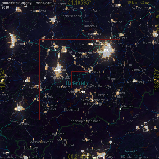
Analysis of Hartenstein night lights 2016
Square area 10x10 km:
 0%
0%90-99
0%80-89
0%70-79
0%60-69
0%50-59
0.4%40-49
0.4%30-39
0.8%20-29
0%10-19
0%0-9
98.4%Square area 50x50 km:
1.26%90-99
1.56%80-89
0.92%70-79
0.99%60-69
1.22%50-59
1.56%40-49
1%30-39
0.95%20-29
2.25%10-19
6.13%0-9
82.16%Clear (daylight) street map image can be seen on geolist.org.
Map coordinates:
51° 6' 21.4" North, 11° 57' 59.5" East
50° 39' 44.5" North, 12° 40' 10.8" East
50° 12' 52.3" North, 13° 22' 22" East
Some cities around Hartenstein sort by population:
• Aue
8.4 km =5.2 mi,  161°
161°
• Schneeberg
7.8 km =4.8 mi,  194°
194°
• Stollberg
9.4 km =5.8 mi,  55°
55°
• Oelsnitz
7.4 km =4.6 mi,  17°
17°
• Lößnitz
6.3 km =3.9 mi,  135°
135°
• Reinsdorf
9 km =5.6 mi,  296°
296°
• Lugau
10.1 km =6.3 mi,  33°
33°
• Bad Schlema
6.7 km =4.2 mi,  178°
178°
2910167 (p: 5,043)
Sources (retrieved 2019-11-25):
» Earth at Night: Flat Maps 2012, 2016