Östringen night lights from space
Night Light of Östringen (Baden-Württemberg) from space (Germany) Src. Average luminocity for 10x10km area is 14.6818% and for 50x50km: 17.801%.
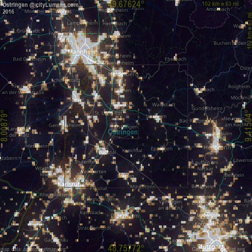
Analysis of Östringen night lights 2016
Square area 10x10 km:
 0.67%
0.67%90-99
1.74%80-89
1.34%70-79
0.8%60-69
2.01%50-59
2.14%40-49
3.61%30-39
3.21%20-29
4.01%10-19
19.39%0-9
61.1%Square area 50x50 km:
2.37%90-99
2.83%80-89
1.83%70-79
1.6%60-69
2.06%50-59
2.02%40-49
2.25%30-39
2.79%20-29
6.94%10-19
18.4%0-9
56.9%Clear (daylight) street map image can be seen on geolist.org.
Map coordinates:
49° 40' 34.5" North, 8° 0' 31.6" East
49° 13' 8.8" North, 8° 42' 42.9" East
48° 45' 27.8" North, 9° 24' 54.1" East
Some cities around Östringen sort by population:
• Wiesloch
8.5 km =5.3 mi,  353°
353°
• Kraichtal
8.2 km =5.1 mi,  169°
169°
• Ubstadt-Weiher
8.5 km =5.3 mi,  223°
223°
• Sankt Leon-Rot
8.6 km =5.3 mi,  307°
307°
• Dielheim
7.5 km =4.7 mi,  14°
14°
• Mühlhausen
3.5 km =2.2 mi,  18°
18°
• Rauenberg
5.6 km =3.5 mi, 353°
• Kronau
5.9 km =3.7 mi,  273°
273°
2856207 (p: 12,880)
Sources (retrieved 2019-11-25):
» Earth at Night: Flat Maps 2012, 2016