Olfen night lights from space
Night Light of Olfen (North Rhine-Westphalia) from space (Germany) Src. Average luminocity for 10x10km area is 2.7577% and for 50x50km: 23.3595%.
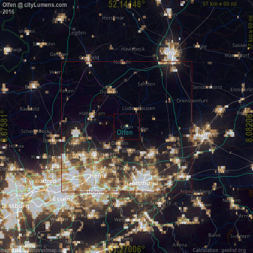
Analysis of Olfen night lights 2016
Square area 10x10 km:
 0%
0%90-99
0%80-89
0.56%70-79
0%60-69
0%50-59
0.56%40-49
0.56%30-39
0.56%20-29
0.56%10-19
0.14%0-9
97.06%Square area 50x50 km:
3.87%90-99
4.33%80-89
2.44%70-79
3.22%60-69
3.8%50-59
3.98%40-49
3.26%30-39
3.41%20-29
5.61%10-19
10.15%0-9
55.94%Clear (daylight) street map image can be seen on geolist.org.
Map coordinates:
52° 8' 29.3" North, 6° 40' 32.9" East
51° 42' 28.3" North, 7° 22' 44.1" East
51° 16' 12.2" North, 8° 4' 55.4" East
Some cities around Olfen sort by population:
• Lünen
14.5 km =9 mi,  134°
134°
• Haltern am See
14.1 km =8.8 mi,  286°
286°
• Datteln
6.2 km =3.9 mi,  201°
201°
• Oer-Erkenschwick
10.8 km =6.7 mi,  227°
227°
• Waltrop
9.8 km =6.1 mi,  170°
170°
• Selm
6.3 km =3.9 mi,  101°
101°
• Lüdinghausen
8.1 km =5 mi,  33°
33°
• Nordkirchen
10.4 km =6.5 mi,  71°
71°
2857363 (p: 12,133)
Sources (retrieved 2019-11-25):
» Earth at Night: Flat Maps 2012, 2016