Nordkirchen night lights from space
Night Light of Nordkirchen (North Rhine-Westphalia) from space (Germany) Src. Average luminocity for 10x10km area is 2.07% and for 50x50km: 17.2112%.
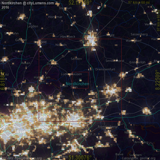
Analysis of Nordkirchen night lights 2016
Square area 10x10 km:
 0%
0%90-99
0%80-89
0.42%70-79
0.14%60-69
0.84%50-59
0%40-49
0%30-39
0.84%20-29
1.26%10-19
0.7%0-9
95.8%Square area 50x50 km:
2.29%90-99
2.64%80-89
1.26%70-79
1.93%60-69
2.92%50-59
3.45%40-49
3.05%30-39
3.32%20-29
5.09%10-19
10.53%0-9
63.52%Clear (daylight) street map image can be seen on geolist.org.
Map coordinates:
52° 10' 17.7" North, 6° 49' 7.8" East
51° 44' 17.8" North, 7° 31' 19.1" East
51° 18' 2.7" North, 8° 13' 30.3" East
Some cities around Nordkirchen sort by population:
• Lünen
13.6 km =8.5 mi,  178°
178°
• Datteln
15.2 km =9.4 mi,  233°
233°
• Werne
11.3 km =7 mi,  136°
136°
• Selm
5.9 km =3.7 mi,  218°
218°
• Lüdinghausen
6.3 km =3.9 mi,  301°
301°
• Senden
13.4 km =8.3 mi,  348°
348°
• Ascheberg
8.2 km =5.1 mi,  52°
52°
• Olfen
10.4 km =6.5 mi,  251°
251°
2861923 (p: 10,231)
Sources (retrieved 2019-11-25):
» Earth at Night: Flat Maps 2012, 2016