Oelsnitz night lights from space
Night Light of Oelsnitz (Saxony) from space (Germany) Src. Average luminocity for 10x10km area is 4.2171% and for 50x50km: 3.3725%.
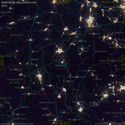
Analysis of Oelsnitz night lights 2016
Square area 10x10 km:
 0.28%
0.28%90-99
0.84%80-89
0%70-79
0%60-69
1.12%50-59
1.12%40-49
0.28%30-39
0.28%20-29
0%10-19
0.56%0-9
95.52%Square area 50x50 km:
0.36%90-99
0.51%80-89
0.41%70-79
0.43%60-69
0.37%50-59
0.54%40-49
0.43%30-39
0.53%20-29
0.27%10-19
1.78%0-9
94.38%Clear (daylight) street map image can be seen on geolist.org.
Map coordinates:
50° 51' 38.3" North, 11° 27' 59" East
50° 24' 52.9" North, 12° 10' 10.2" East
49° 57' 52.3" North, 12° 52' 21.5" East
Some cities around Oelsnitz sort by population:
• Plauen
9.5 km =5.9 mi,  346°
346°
• Auerbach
19.6 km =12.2 mi,  56°
56°
• Aš, CZ
21.3 km =13.2 mi,  175°
175°
• Rehau
20.8 km =12.9 mi,  207°
207°
• Falkenstein
15.9 km =9.9 mi, 63°
• Treuen
17.1 km =10.6 mi,  33°
33°
• Markneukirchen
16.1 km =10 mi,  135°
135°
• Adorf
12.3 km =7.6 mi,  148°
148°
2857919 (p: 12,686)
Sources (retrieved 2019-11-25):
» Earth at Night: Flat Maps 2012, 2016