Markneukirchen night lights from space
Night Light of Markneukirchen (Saxony) from space (Germany) Src. Average luminocity for 10x10km area is 1.2701% and for 50x50km: 3.0564%.
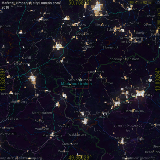
Analysis of Markneukirchen night lights 2016
Square area 10x10 km:
 0%
0%90-99
0%80-89
0%70-79
0.27%60-69
0.53%50-59
0%40-49
0.53%30-39
0.94%20-29
0.4%10-19
0%0-9
97.33%Square area 50x50 km:
0.5%90-99
0.53%80-89
0.31%70-79
0.27%60-69
0.26%50-59
0.35%40-49
0.36%30-39
0.52%20-29
0.32%10-19
1.8%0-9
94.78%Clear (daylight) street map image can be seen on geolist.org.
Map coordinates:
50° 45' 30.1" North, 11° 37' 35" East
50° 18' 41.2" North, 12° 19' 46.2" East
49° 51' 37" North, 13° 1' 57.5" East
Some cities around Markneukirchen sort by population:
• Selb
21.1 km =13.1 mi,  222°
222°
• Aš, CZ
13.6 km =8.5 mi, 224°
• Oelsnitz
16.1 km =10 mi,  315°
315°
• Falkenstein
18.7 km =11.6 mi,  9°
9°
• Klingenthal
11 km =6.8 mi,  60°
60°
• Kraslice, CZ
13.4 km =8.3 mi,  84°
84°
• Adorf
5 km =3.1 mi,  281°
281°
• Habartov, CZ
21.2 km =13.2 mi,  132°
132°
2873340 (p: 7,095)
Sources (retrieved 2019-11-25):
» Earth at Night: Flat Maps 2012, 2016