Nideggen night lights from space
Night Light of Nideggen (North Rhine-Westphalia) from space (Germany) Src. Average luminocity for 10x10km area is 1.6243% and for 50x50km: 10.3514%.
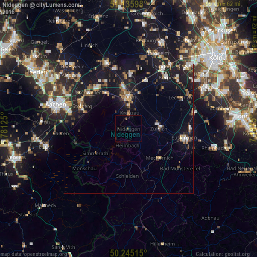
Analysis of Nideggen night lights 2016
Square area 10x10 km:
 0%
0%90-99
0%80-89
0%70-79
0.53%60-69
0.4%50-59
0.13%40-49
0.13%30-39
0.4%20-29
0.53%10-19
0.27%0-9
97.59%Square area 50x50 km:
1.09%90-99
1.43%80-89
0.82%70-79
1.02%60-69
1.42%50-59
1.71%40-49
1.48%30-39
1.38%20-29
3.34%10-19
12.57%0-9
73.73%Clear (daylight) street map image can be seen on geolist.org.
Map coordinates:
51° 8' 9.5" North, 5° 46' 52.5" East
50° 41' 33.6" North, 6° 29' 3.7" East
50° 14' 42.5" North, 7° 11' 15" East
Some cities around Nideggen sort by population:
• Düren
12.4 km =7.7 mi,  2°
2°
• Mechernich
16.2 km =10.1 mi,  133°
133°
• Zulpich
12 km =7.5 mi,  89°
89°
• Kreuzau
6.1 km =3.8 mi, 4°
• Simmerath
16.6 km =10.3 mi,  231°
231°
• Nörvenich
16.7 km =10.4 mi,  40°
40°
• Vettweiß
9.3 km =5.8 mi,  60°
60°
• Hürtgenwald
8.7 km =5.4 mi,  287°
287°
2863711 (p: 10,727)
Sources (retrieved 2019-11-25):
» Earth at Night: Flat Maps 2012, 2016