Kreuzau night lights from space
Night Light of Kreuzau (North Rhine-Westphalia) from space (Germany) Src. Average luminocity for 10x10km area is 10.3008% and for 50x50km: 12.6191%.
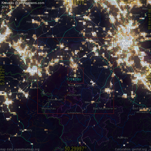
Analysis of Kreuzau night lights 2016
Square area 10x10 km:
 0.4%
0.4%90-99
0.4%80-89
0.8%70-79
1.47%60-69
1.6%50-59
2.27%40-49
2.27%30-39
0.53%20-29
1.87%10-19
15.24%0-9
73.13%Square area 50x50 km:
1.3%90-99
1.73%80-89
1.02%70-79
1.26%60-69
1.76%50-59
2.09%40-49
1.82%30-39
1.79%20-29
3.88%10-19
15.16%0-9
68.19%Clear (daylight) street map image can be seen on geolist.org.
Map coordinates:
51° 11' 23.2" North, 5° 47' 15.3" East
50° 44' 49.2" North, 6° 29' 26.5" East
50° 17' 59.9" North, 7° 11' 37.8" East
Some cities around Kreuzau sort by population:
• Düren
6.4 km =4 mi,  1°
1°
• Zulpich
12.9 km =8 mi,  116°
116°
• Langerwehe
12.6 km =7.8 mi,  308°
308°
• Nörvenich
12.4 km =7.7 mi,  57°
57°
• Nideggen
6.1 km =3.8 mi,  184°
184°
• Vettweiß
7.8 km =4.8 mi,  101°
101°
• Hürtgenwald
9.4 km =5.8 mi,  248°
248°
• Inden
14.1 km =8.8 mi,  319°
319°
2884245 (p: 18,400)
Sources (retrieved 2019-11-25):
» Earth at Night: Flat Maps 2012, 2016