Hürtgenwald night lights from space
Night Light of Hürtgenwald (North Rhine-Westphalia) from space (Germany) Src. Average luminocity for 10x10km area is 0.5481% and for 50x50km: 13.8136%.
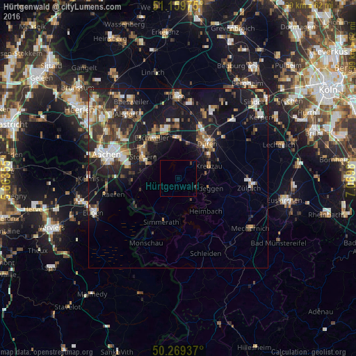
Analysis of Hürtgenwald night lights 2016
Square area 10x10 km:
 0%
0%90-99
0%80-89
0%70-79
0%60-69
0%50-59
0%40-49
0%30-39
0.8%20-29
0.27%10-19
0%0-9
98.93%Square area 50x50 km:
1.74%90-99
2.35%80-89
1.25%70-79
1.42%60-69
1.7%50-59
2.22%40-49
1.93%30-39
2.28%20-29
4.78%10-19
12.55%0-9
67.77%Clear (daylight) street map image can be seen on geolist.org.
Map coordinates:
51° 9' 35.1" North, 5° 39' 48.8" East
50° 43' 0" North, 6° 22' 0" East
50° 16' 9.7" North, 7° 4' 11.3" East
Some cities around Hürtgenwald sort by population:
• Düren
13.2 km =8.2 mi,  42°
42°
• Stolberg
11.8 km =7.3 mi,  302°
302°
• Eschweiler
13.1 km =8.1 mi,  329°
329°
• Kreuzau
9.4 km =5.8 mi,  68°
68°
• Simmerath
13.8 km =8.6 mi,  199°
199°
• Langerwehe
11.2 km =7 mi,  353°
353°
• Nideggen
8.7 km =5.4 mi,  107°
107°
• Roetgen
13.9 km =8.6 mi,  237°
237°
2897219 (p: 8,876)
Sources (retrieved 2019-11-25):
» Earth at Night: Flat Maps 2012, 2016