Simmerath night lights from space
Night Light of Simmerath (North Rhine-Westphalia) from space (Germany) Src. Average luminocity for 10x10km area is 0.6618% and for 50x50km: 7.5096%.
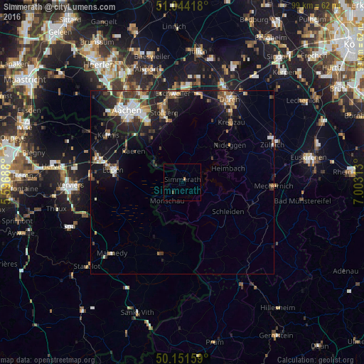
Analysis of Simmerath night lights 2016
Square area 10x10 km:
 0%
0%90-99
0%80-89
0%70-79
0%60-69
0.53%50-59
0%40-49
0.53%30-39
0%20-29
0%10-19
0%0-9
98.93%Square area 50x50 km:
1.03%90-99
1.28%80-89
0.7%70-79
0.62%60-69
0.95%50-59
1.17%40-49
1.08%30-39
1.29%20-29
2.28%10-19
6.31%0-9
83.29%Clear (daylight) street map image can be seen on geolist.org.
Map coordinates:
51° 2' 39" North, 5° 35' 48.8" East
50° 36' 0" North, 6° 18' 0" East
50° 9' 5.7" North, 7° 0' 11.3" East
Some cities around Simmerath sort by population:
• Eupen, BE
18.9 km =11.7 mi,  279°
279°
• Schleiden
14.8 km =9.2 mi,  122°
122°
• Monschau
6.6 km =4.1 mi,  220°
220°
• Nideggen
16.6 km =10.3 mi,  51°
51°
• Raeren, BE
15 km =9.3 mi,  299°
299°
• Hürtgenwald
13.8 km =8.6 mi,  19°
19°
• Hellenthal
16 km =9.9 mi,  144°
144°
• Roetgen
9 km =5.6 mi,  308°
308°
2832023 (p: 15,646)
Sources (retrieved 2019-11-25):
» Earth at Night: Flat Maps 2012, 2016