Montabaur night lights from space
Night Light of Montabaur (Rheinland-Pfalz) from space (Germany) Src. Average luminocity for 10x10km area is 11.1148% and for 50x50km: 6.2375%.
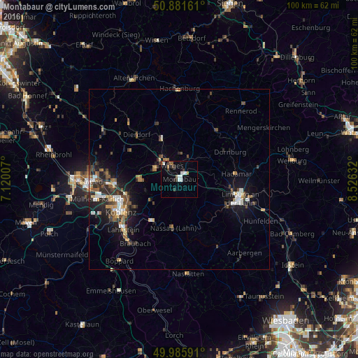
Analysis of Montabaur night lights 2016
Square area 10x10 km:
 2.38%
2.38%90-99
2.1%80-89
0%70-79
0.42%60-69
1.26%50-59
1.68%40-49
0.56%30-39
3.36%20-29
0.56%10-19
1.82%0-9
85.85%Square area 50x50 km:
0.75%90-99
0.95%80-89
0.5%70-79
0.54%60-69
0.79%50-59
1.19%40-49
1.03%30-39
0.87%20-29
1.96%10-19
4.43%0-9
86.98%Clear (daylight) street map image can be seen on geolist.org.
Map coordinates:
50° 52' 53.8" North, 7° 7' 12.3" East
50° 26' 9.2" North, 7° 49' 23.5" East
49° 59' 9.3" North, 8° 31' 34.8" East
Some cities around Montabaur sort by population:
• Diez
14.7 km =9.1 mi,  117°
117°
• Höhr-Grenzhausen
10.9 km =6.8 mi,  269°
269°
• Bad Ems
13.6 km =8.5 mi,  214°
214°
• Vallendar
14.8 km =9.2 mi,  252°
252°
• Elz
15 km =9.3 mi,  98°
98°
• Ransbach-Baumbach
7.5 km =4.7 mi,  295°
295°
• Wirges
4.4 km =2.7 mi,  336°
336°
• Nassau
13.6 km =8.5 mi,  186°
186°
2869746 (p: 12,345)
Sources (retrieved 2019-11-25):
» Earth at Night: Flat Maps 2012, 2016