Wirges night lights from space
Night Light of Wirges (Rheinland-Pfalz) from space (Germany) Src. Average luminocity for 10x10km area is 16.091% and for 50x50km: 6.6074%.
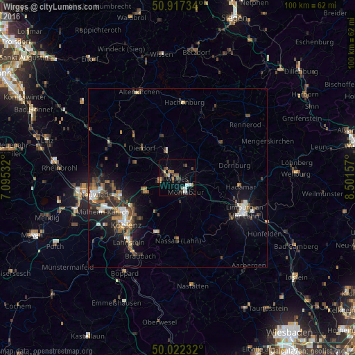
Analysis of Wirges night lights 2016
Square area 10x10 km:
 2.38%
2.38%90-99
2.1%80-89
0.7%70-79
1.26%60-69
2.94%50-59
2.66%40-49
2.38%30-39
4.06%20-29
1.54%10-19
2.24%0-9
77.73%Square area 50x50 km:
0.83%90-99
1.01%80-89
0.52%70-79
0.57%60-69
0.8%50-59
1.27%40-49
1.13%30-39
0.98%20-29
2.06%10-19
4.67%0-9
86.17%Clear (daylight) street map image can be seen on geolist.org.
Map coordinates:
50° 55' 2.4" North, 7° 5' 43.2" East
50° 28' 19" North, 7° 47' 54.4" East
50° 1' 20.4" North, 8° 30' 5.7" East
Some cities around Wirges sort by population:
• Bendorf
16.5 km =10.3 mi,  250°
250°
• Montabaur
4.4 km =2.7 mi,  156°
156°
• Höhr-Grenzhausen
10.1 km =6.3 mi, 245°
• Bad Ems
16.3 km =10.1 mi,  201°
201°
• Vallendar
15 km =9.3 mi,  235°
235°
• Ransbach-Baumbach
5 km =3.1 mi,  261°
261°
• Dierdorf
13.2 km =8.2 mi,  308°
308°
• Westerburg
15.8 km =9.8 mi,  52°
52°
2807549 (p: 5,201)
Sources (retrieved 2019-11-25):
» Earth at Night: Flat Maps 2012, 2016