Elz night lights from space
Night Light of Elz (Hesse) from space (Germany) Src. Average luminocity for 10x10km area is 20.1541% and for 50x50km: 2.6532%.
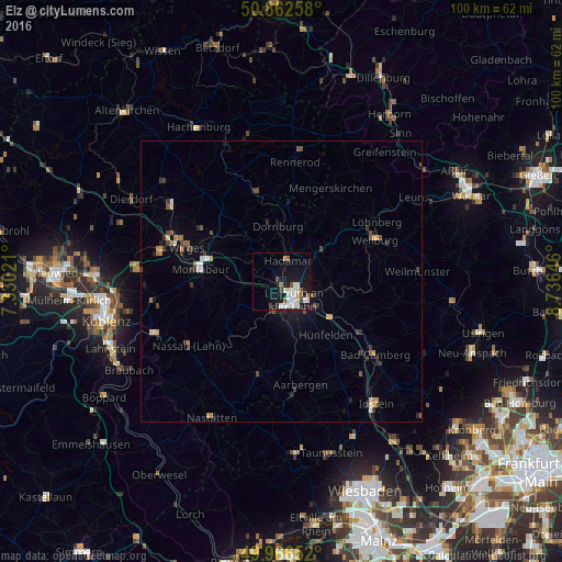
Analysis of Elz night lights 2016
Square area 10x10 km:
 4.48%
4.48%90-99
6.3%80-89
1.4%70-79
1.26%60-69
0.98%50-59
2.66%40-49
1.4%30-39
1.12%20-29
1.26%10-19
18.07%0-9
61.06%Square area 50x50 km:
0.28%90-99
0.4%80-89
0.2%70-79
0.27%60-69
0.27%50-59
0.45%40-49
0.35%30-39
0.57%20-29
0.38%10-19
1.55%0-9
95.26%Clear (daylight) street map image can be seen on geolist.org.
Map coordinates:
50° 51' 45.3" North, 7° 19' 48.8" East
50° 25' 0" North, 8° 1' 60" East
49° 57' 59.5" North, 8° 44' 11.3" East
Some cities around Elz sort by population:
• Limburg an der Lahn
3.9 km =2.4 mi,  161°
161°
• Montabaur
15 km =9.3 mi,  278°
278°
• Hadamar
3.3 km =2.1 mi,  11°
11°
• Diez
5.1 km =3.2 mi,  201°
201°
• Runkel
8.7 km =5.4 mi,  98°
98°
• Villmar
11.6 km =7.2 mi, 103°
• Waldbrunn
12.5 km =7.8 mi,  25°
25°
• Westerburg
16.4 km =10.2 mi,  345°
345°
2930628 (p: 7,972)
Sources (retrieved 2019-11-25):
» Earth at Night: Flat Maps 2012, 2016