Diez night lights from space
Night Light of Diez (Rheinland-Pfalz) from space (Germany) Src. Average luminocity for 10x10km area is 16.923% and for 50x50km: 2.9551%.
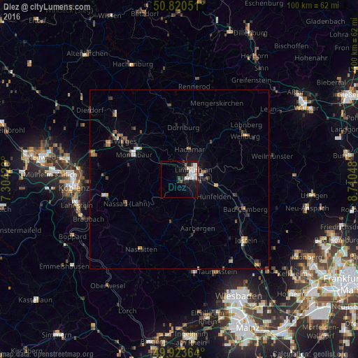
Analysis of Diez night lights 2016
Square area 10x10 km:
 3.92%
3.92%90-99
5.74%80-89
1.4%70-79
0.7%60-69
0.14%50-59
1.82%40-49
1.12%30-39
0.7%20-29
1.68%10-19
15.55%0-9
67.23%Square area 50x50 km:
0.28%90-99
0.4%80-89
0.23%70-79
0.36%60-69
0.36%50-59
0.5%40-49
0.34%30-39
0.62%20-29
0.44%10-19
1.57%0-9
94.91%Clear (daylight) street map image can be seen on geolist.org.
Map coordinates:
50° 49' 13.8" North, 7° 18' 15.2" East
50° 22' 27.1" North, 8° 0' 26.5" East
49° 55' 25.1" North, 8° 42' 37.7" East
Some cities around Diez sort by population:
• Limburg an der Lahn
3.2 km =2 mi,  71°
71°
• Montabaur
14.7 km =9.1 mi,  297°
297°
• Hadamar
8.4 km =5.2 mi,  17°
17°
• Runkel
11 km =6.8 mi, 71°
• Elz
5.1 km =3.2 mi, 21°
• Villmar
13.3 km =8.3 mi,  81°
81°
• Waldbrunn
17.6 km =10.9 mi, 23°
• Nassau
16.1 km =10 mi,  245°
245°
2937018 (p: 10,822)
Sources (retrieved 2019-11-25):
» Earth at Night: Flat Maps 2012, 2016