Meckesheim night lights from space
Night Light of Meckesheim (Baden-Württemberg) from space (Germany) Src. Average luminocity for 10x10km area is 2.9906% and for 50x50km: 16.0399%.
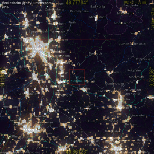
Analysis of Meckesheim night lights 2016
Square area 10x10 km:
 0%
0%90-99
0%80-89
0%70-79
0%60-69
0%50-59
1.07%40-49
0.13%30-39
1.6%20-29
1.74%10-19
0.4%0-9
95.05%Square area 50x50 km:
2.5%90-99
3.1%80-89
1.52%70-79
1.23%60-69
1.8%50-59
1.86%40-49
1.99%30-39
2.58%20-29
6.07%10-19
13.28%0-9
64.08%Clear (daylight) street map image can be seen on geolist.org.
Map coordinates:
49° 46' 40.2" North, 8° 6' 58.7" East
49° 19' 18" North, 8° 49' 10" East
48° 51' 40.4" North, 9° 31' 21.2" East
Some cities around Meckesheim sort by population:
• Sinsheim
8.8 km =5.5 mi,  150°
150°
• Leimen
10 km =6.2 mi,  286°
286°
• Wiesloch
9.3 km =5.8 mi,  251°
251°
• Neckargemünd
7.7 km =4.8 mi,  347°
347°
• Nußloch
9 km =5.6 mi,  271°
271°
• Dielheim
7.2 km =4.5 mi,  234°
234°
• Bammental
4.8 km =3 mi,  322°
322°
• Waibstadt
7.7 km =4.8 mi,  112°
112°
2872580 (p: 5,409)
Sources (retrieved 2019-11-25):
» Earth at Night: Flat Maps 2012, 2016