Neckargemünd night lights from space
Night Light of Neckargemünd (Baden-Württemberg) from space (Germany) Src. Average luminocity for 10x10km area is 6.5214% and for 50x50km: 16.4296%.
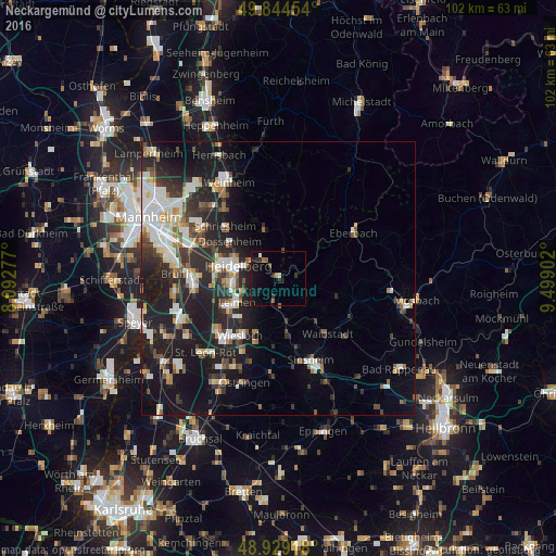
Analysis of Neckargemünd night lights 2016
Square area 10x10 km:
 0%
0%90-99
0.53%80-89
0.53%70-79
0.27%60-69
1.07%50-59
1.34%40-49
0.8%30-39
0.94%20-29
2.27%10-19
9.36%0-9
82.89%Square area 50x50 km:
2.82%90-99
3.36%80-89
1.49%70-79
1.15%60-69
1.67%50-59
1.82%40-49
1.89%30-39
2.63%20-29
6.63%10-19
13.55%0-9
62.98%Clear (daylight) street map image can be seen on geolist.org.
Map coordinates:
49° 50' 40.3" North, 8° 5' 34" East
49° 23' 20.4" North, 8° 47' 45.2" East
48° 55' 45" North, 9° 29' 56.5" East
Some cities around Neckargemünd sort by population:
• Heidelberg
7.9 km =4.9 mi,  285°
285°
• Leimen
9.1 km =5.7 mi,  239°
239°
• Sandhausen
11.2 km =7 mi, 242°
• Eppelheim
11.6 km =7.2 mi,  277°
277°
• Dossenheim
11.1 km =6.9 mi,  307°
307°
• Nußloch
10.3 km =6.4 mi,  225°
225°
• Bammental
3.8 km =2.4 mi,  198°
198°
• Meckesheim
7.7 km =4.8 mi,  167°
167°
2866774 (p: 14,335)
Sources (retrieved 2019-11-25):
» Earth at Night: Flat Maps 2012, 2016