Lugau night lights from space
Night Light of Lugau (Saxony) from space (Germany) Src. Average luminocity for 10x10km area is 8.2914% and for 50x50km: 9.2904%.
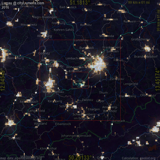
Analysis of Lugau night lights 2016
Square area 10x10 km:
 0.8%
0.8%90-99
0.8%80-89
0.94%70-79
0.13%60-69
1.6%50-59
2.67%40-49
2.14%30-39
0.8%20-29
0%10-19
0.8%0-9
89.3%Square area 50x50 km:
1.23%90-99
1.56%80-89
0.96%70-79
0.88%60-69
1.24%50-59
1.45%40-49
0.97%30-39
0.94%20-29
2.32%10-19
6.67%0-9
81.78%Clear (daylight) street map image can be seen on geolist.org.
Map coordinates:
51° 10' 52.7" North, 12° 2' 43.8" East
50° 44' 18.3" North, 12° 44' 55" East
50° 17' 28.8" North, 13° 27' 6.3" East
Some cities around Lugau sort by population:
• Hohenstein-Ernstthal
7.4 km =4.6 mi,  340°
340°
• Lichtenstein
8.6 km =5.3 mi,  283°
283°
• Stollberg
3.9 km =2.4 mi,  144°
144°
• Oelsnitz
3.6 km =2.2 mi,  247°
247°
• Thalheim
8.3 km =5.2 mi,  120°
120°
• Neukirchen
9.5 km =5.9 mi,  61°
61°
• Oberlungwitz
5.7 km =3.5 mi,  329°
329°
• Jahnsdorf
7.5 km =4.7 mi,  84°
84°
2875286 (p: 7,671)
Sources (retrieved 2019-11-25):
» Earth at Night: Flat Maps 2012, 2016