Lichtenau night lights from space
Night Light of Lichtenau (North Rhine-Westphalia) from space (Germany) Src. Average luminocity for 10x10km area is 0% and for 50x50km: 3.5744%.
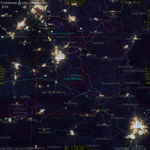
Analysis of Lichtenau night lights 2016
Square area 10x10 km:
 0%
0%90-99
0%80-89
0%70-79
0%60-69
0%50-59
0%40-49
0%30-39
0%20-29
0%10-19
0%0-9
100%Square area 50x50 km:
0.45%90-99
0.6%80-89
0.36%70-79
0.45%60-69
0.5%50-59
0.54%40-49
0.46%30-39
0.46%20-29
0.8%10-19
2.36%0-9
93.02%Clear (daylight) street map image can be seen on geolist.org.
Map coordinates:
52° 3' 5.6" North, 8° 11' 36.7" East
51° 37' 1.5" North, 8° 53' 47.9" East
51° 10' 42.2" North, 9° 35' 59.2" East
Some cities around Lichtenau sort by population:
• Paderborn
15 km =9.3 mi,  319°
319°
• Salzkotten
21.3 km =13.2 mi,  286°
286°
• Marsberg
17.6 km =10.9 mi,  190°
190°
• Bad Driburg
15.4 km =9.6 mi,  33°
33°
• Bad Lippspringe
19.3 km =12 mi,  343°
343°
• Wünnenberg
17.4 km =10.8 mi,  231°
231°
• Altenbeken
16.7 km =10.4 mi,  10°
10°
• Willebadessen
9.7 km =6 mi,  84°
84°
2878133 (p: 11,268)
Sources (retrieved 2019-11-25):
» Earth at Night: Flat Maps 2012, 2016