Altenbeken night lights from space
Night Light of Altenbeken (North Rhine-Westphalia) from space (Germany) Src. Average luminocity for 10x10km area is 1.049% and for 50x50km: 4.3995%.
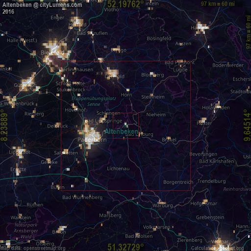
Analysis of Altenbeken night lights 2016
Square area 10x10 km:
 0%
0%90-99
0%80-89
0.56%70-79
0%60-69
0%50-59
0.28%40-49
0.56%30-39
0%20-29
0%10-19
0%0-9
98.6%Square area 50x50 km:
0.5%90-99
0.69%80-89
0.57%70-79
0.46%60-69
0.58%50-59
0.55%40-49
0.57%30-39
0.47%20-29
0.96%10-19
3.3%0-9
91.34%Clear (daylight) street map image can be seen on geolist.org.
Map coordinates:
52° 11' 51.4" North, 8° 14' 20" East
51° 45' 52.4" North, 8° 56' 31.2" East
51° 19' 38.2" North, 9° 38' 42.5" East
Some cities around Altenbeken sort by population:
• Paderborn
13.9 km =8.6 mi,  248°
248°
• Bad Driburg
6.4 km =4 mi,  123°
123°
• Bad Lippspringe
8.9 km =5.5 mi,  283°
283°
• Steinheim
15.6 km =9.7 mi,  41°
41°
• Lichtenau
16.7 km =10.4 mi,  190°
190°
• Schlangen
8.3 km =5.2 mi,  307°
307°
• Horn
11.9 km =7.4 mi,  1°
1°
• Nieheim
12.6 km =7.8 mi,  69°
69°
2957864 (p: 9,716)
Sources (retrieved 2019-11-25):
» Earth at Night: Flat Maps 2012, 2016