Leopoldshöhe night lights from space
Night Light of Leopoldshöhe (North Rhine-Westphalia) from space (Germany) Src. Average luminocity for 10x10km area is 4.2563% and for 50x50km: 8.1809%.
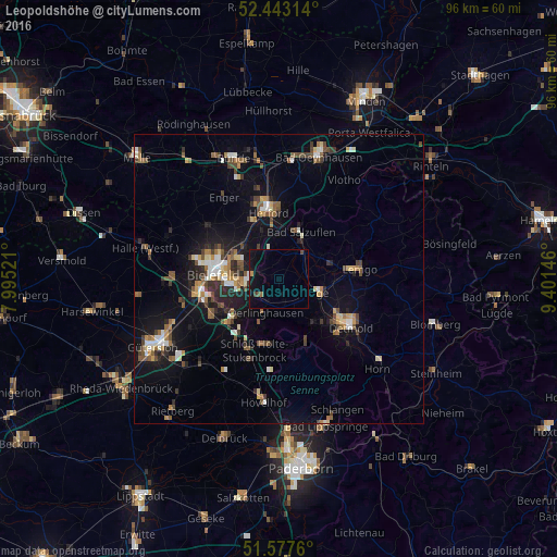
Analysis of Leopoldshöhe night lights 2016
Square area 10x10 km:
 0.38%
0.38%90-99
0.13%80-89
0%70-79
0.51%60-69
0%50-59
0.51%40-49
1.01%30-39
0.63%20-29
0.13%10-19
6.82%0-9
89.9%Square area 50x50 km:
0.79%90-99
1.07%80-89
0.8%70-79
0.75%60-69
1.14%50-59
1.37%40-49
1.58%30-39
1%20-29
1.72%10-19
6.08%0-9
83.7%Clear (daylight) street map image can be seen on geolist.org.
Map coordinates:
52° 26' 35.3" North, 7° 59' 42.8" East
52° 0' 44.9" North, 8° 41' 54" East
51° 34' 39.4" North, 9° 24' 5.3" East
Some cities around Leopoldshöhe sort by population:
• Bielefeld
11.5 km =7.1 mi,  281°
281°
• Detmold
14.5 km =9 mi,  124°
124°
• Herford
11.5 km =7.1 mi,  351°
351°
• Bad Salzuflen
8.8 km =5.5 mi,  20°
20°
• Lemgo
13.8 km =8.6 mi,  82°
82°
• Lage
6.9 km =4.3 mi,  109°
109°
• Oerlinghausen
6.9 km =4.3 mi,  201°
201°
• Augustdorf
11.7 km =7.3 mi,  168°
168°
2878673 (p: 16,219)
Sources (retrieved 2019-11-25):
» Earth at Night: Flat Maps 2012, 2016