Flein night lights from space
Night Light of Flein (Baden-Württemberg) from space (Germany) Src. Average luminocity for 10x10km area is 27.5518% and for 50x50km: 12.7599%.
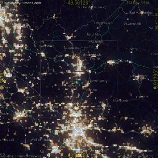
Analysis of Flein night lights 2016
Square area 10x10 km:
 3.08%
3.08%90-99
2.66%80-89
1.96%70-79
3.5%60-69
3.22%50-59
4.62%40-49
3.64%30-39
4.62%20-29
9.66%10-19
49.02%0-9
14.01%Square area 50x50 km:
1.44%90-99
1.7%80-89
1.19%70-79
1.32%60-69
1.72%50-59
1.89%40-49
1.86%30-39
2.11%20-29
3.6%10-19
10.19%0-9
72.99%Clear (daylight) street map image can be seen on geolist.org.
Map coordinates:
49° 33' 40.5" North, 8° 30' 27.7" East
49° 6' 11" North, 9° 12' 39" East
48° 38' 26.1" North, 9° 54' 50.2" East
Some cities around Flein sort by population:
• Heilbronn
4.2 km =2.6 mi,  9°
9°
• Weinsberg
7.7 km =4.8 mi,  46°
46°
• Lauffen am Neckar
5.8 km =3.6 mi,  235°
235°
• Leingarten
8.4 km =5.2 mi,  305°
305°
• Ilsfeld
5.9 km =3.7 mi,  154°
154°
• Untergruppenbach
4.9 km =3 mi,  107°
107°
• Nordheim
6.1 km =3.8 mi,  275°
275°
• Kirchheim am Neckar
8.2 km =5.1 mi,  217°
217°
2926304 (p: 6,558)
Sources (retrieved 2019-11-25):
» Earth at Night: Flat Maps 2012, 2016