Bad Wimpfen night lights from space
Night Light of Bad Wimpfen (Baden-Württemberg) from space (Germany) Src. Average luminocity for 10x10km area is 23.5602% and for 50x50km: 7.1032%.
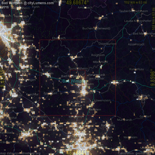
Analysis of Bad Wimpfen night lights 2016
Square area 10x10 km:
 3.74%
3.74%90-99
2.14%80-89
0.8%70-79
2.67%60-69
5.88%50-59
5.75%40-49
1.34%30-39
2.14%20-29
7.49%10-19
17.38%0-9
50.67%Square area 50x50 km:
0.79%90-99
0.73%80-89
0.53%70-79
0.69%60-69
0.94%50-59
1.29%40-49
1.17%30-39
1.42%20-29
1.73%10-19
4.66%0-9
86.04%Clear (daylight) street map image can be seen on geolist.org.
Map coordinates:
49° 41' 12.3" North, 8° 27' 12.1" East
49° 13' 47" North, 9° 9' 23.3" East
48° 46' 6.3" North, 9° 51' 34.6" East
Some cities around Bad Wimpfen sort by population:
• Heilbronn
11 km =6.8 mi,  154°
154°
• Neckarsulm
6.7 km =4.2 mi,  132°
132°
• Bad Rappenau
4.1 km =2.5 mi,  283°
283°
• Schwaigern
12 km =7.5 mi,  217°
217°
• Leingarten
9.7 km =6 mi,  197°
197°
• Gundelsheim
6 km =3.7 mi,  2°
2°
• Oedheim
7.1 km =4.4 mi,  80°
80°
• Neudenau
10.7 km =6.6 mi,  49°
49°
2953315 (p: 6,968)
Sources (retrieved 2019-11-25):
» Earth at Night: Flat Maps 2012, 2016