Roetgen night lights from space
Night Light of Roetgen (North Rhine-Westphalia) from space (Germany) Src. Average luminocity for 10x10km area is 0.9198% and for 50x50km: 12.3086%.
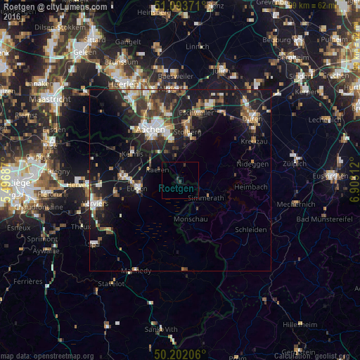
Analysis of Roetgen night lights 2016
Square area 10x10 km:
 0%
0%90-99
0%80-89
0%70-79
0%60-69
0%50-59
0%40-49
0%30-39
1.47%20-29
0.13%10-19
0.53%0-9
97.86%Square area 50x50 km:
1.59%90-99
2.06%80-89
1.11%70-79
0.88%60-69
1.64%50-59
1.9%40-49
1.88%30-39
2.27%20-29
4.17%10-19
11.87%0-9
70.63%Clear (daylight) street map image can be seen on geolist.org.
Map coordinates:
51° 5' 37.4" North, 5° 29' 48.7" East
50° 39' 0" North, 6° 12' 0" East
50° 12' 7.4" North, 6° 54' 11.2" East
Some cities around Roetgen sort by population:
• Stolberg
13.9 km =8.6 mi,  7°
7°
• Eupen, BE
11.8 km =7.3 mi,  257°
257°
• Simmerath
9 km =5.6 mi,  128°
128°
• Monschau
11 km =6.8 mi,  165°
165°
• La Calamine, BE
15.3 km =9.5 mi,  299°
299°
• Raeren, BE
6.3 km =3.9 mi,  287°
287°
• Welkenraedt, BE
16.2 km =10.1 mi,  274°
274°
• Hürtgenwald
13.9 km =8.6 mi,  57°
57°
2844277 (p: 8,177)
Sources (retrieved 2019-11-25):
» Earth at Night: Flat Maps 2012, 2016