Hochfeld night lights from space
Night Light of Hochfeld (North Rhine-Westphalia) from space (Germany) Src. Average luminocity for 10x10km area is 83.6791% and for 50x50km: 44.6322%.
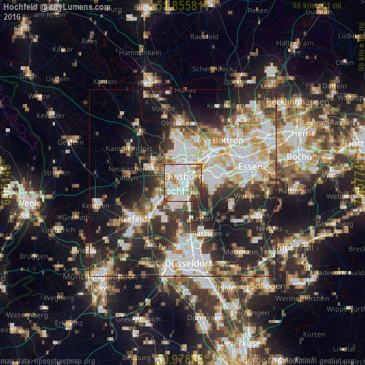
Analysis of Hochfeld night lights 2016
Square area 10x10 km:
 30.61%
90-99
30.08%80-89
4.81%70-79
9.36%60-69
7.75%50-59
6.55%40-49
5.35%30-39
4.41%20-29
1.07%10-19
0%0-9
0%Square area 50x50 km:
10.24%90-99
10.62%80-89
4.59%70-79
4.82%60-69
5.09%50-59
5.06%40-49
5.02%30-39
6.99%20-29
12.63%10-19
16.14%0-9
18.8%Clear (daylight) street map image can be seen on geolist.org.
Map coordinates:
51° 51' 20.9" North, 6° 3' 5.4" East
51° 25' 9.9" North, 6° 45' 16.6" East
50° 58' 43.9" North, 7° 27' 27.9" East
Some cities around Hochfeld sort by population:
• Duisburg
1.6 km =1 mi,  26°
26°
• Oberhausen
9.9 km =6.2 mi,  48°
48°
• Mülheim
8.8 km =5.5 mi,  80°
80°
• Bottrop
16.7 km =10.4 mi, 46°
• Moers
9.3 km =5.8 mi,  294°
294°
• Ratingen
15.1 km =9.4 mi,  154°
154°
• Dinslaken
15.9 km =9.9 mi,  357°
357°
• Meiderich
5.3 km =3.3 mi,  9°
9°
2903237 (p: 16,292)
Sources (retrieved 2019-11-25):
» Earth at Night: Flat Maps 2012, 2016