Hermsdorf night lights from space
Night Light of Hermsdorf (Berlin) from space (Germany) Src. Average luminocity for 10x10km area is 55.6601% and for 50x50km: 32.8833%.
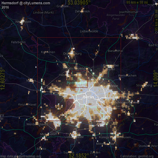
Analysis of Hermsdorf night lights 2016
Square area 10x10 km:
 10.85%
90-99
15.08%80-89
4.37%70-79
5.82%60-69
7.01%50-59
8.2%40-49
6.48%30-39
12.57%20-29
16.67%10-19
12.96%0-9
0%Square area 50x50 km:
10.24%90-99
8.68%80-89
3.31%70-79
2.58%60-69
2.79%50-59
2.87%40-49
3.03%30-39
3.38%20-29
5.83%10-19
9.99%0-9
47.28%Clear (daylight) street map image can be seen on geolist.org.
Map coordinates:
53° 2' 20.6" North, 12° 36' 9.9" East
52° 36' 51.2" North, 13° 18' 21.1" East
52° 11' 6.7" North, 14° 0' 32.4" East
Some cities around Hermsdorf sort by population:
• Märkisches Viertel
3.9 km =2.4 mi,  116°
116°
• Tegel
4.3 km =2.7 mi,  190°
190°
• Wittenau
2.6 km =1.6 mi,  156°
156°
• Heiligensee
4.1 km =2.5 mi,  270°
270°
• Frohnau
2.4 km =1.5 mi,  333°
333°
• Waidmannslust
1.2 km =0.7 mi,  131°
131°
• Glienicke
2.5 km =1.6 mi,  31°
31°
• Rosenthal
5.1 km =3.2 mi,  108°
108°
2905904 (p: 16,113)
Sources (retrieved 2019-11-25):
» Earth at Night: Flat Maps 2012, 2016