Heiligensee night lights from space
Night Light of Heiligensee (Berlin) from space (Germany) Src. Average luminocity for 10x10km area is 43.5172% and for 50x50km: 31.8955%.
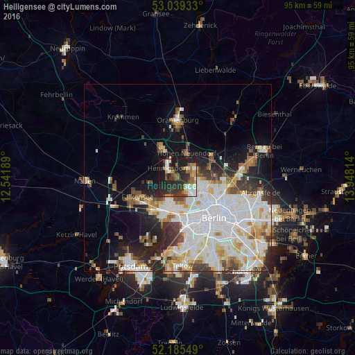
Analysis of Heiligensee night lights 2016
Square area 10x10 km:
 5.69%
5.69%90-99
8.6%80-89
2.51%70-79
4.63%60-69
7.28%50-59
7.01%40-49
5.29%30-39
10.45%20-29
24.34%10-19
23.68%0-9
0.53%Square area 50x50 km:
10.17%90-99
8.48%80-89
3.22%70-79
2.5%60-69
2.74%50-59
2.73%40-49
2.95%30-39
3.19%20-29
5.19%10-19
8.63%0-9
50.21%Clear (daylight) street map image can be seen on geolist.org.
Map coordinates:
53° 2' 21.6" North, 12° 32' 30.8" East
52° 36' 52.2" North, 13° 14' 42" East
52° 11' 7.8" North, 13° 56' 53.3" East
Some cities around Heiligensee sort by population:
• Tegel
5.4 km =3.4 mi,  142°
142°
• Wittenau
5.7 km =3.5 mi,  114°
114°
• Hennigsdorf
3.6 km =2.2 mi,  310°
310°
• Frohnau
3.7 km =2.3 mi,  55°
55°
• Hermsdorf
4.1 km =2.5 mi,  90°
90°
• Waidmannslust
5.1 km =3.2 mi,  99°
99°
• Glienicke
5.8 km =3.6 mi,  68°
68°
• Konradshöhe
3.4 km =2.1 mi,  199°
199°
2907551 (p: 17,587)
Sources (retrieved 2019-11-25):
» Earth at Night: Flat Maps 2012, 2016