Waidmannslust night lights from space
Night Light of Waidmannslust (Berlin) from space (Germany) Src. Average luminocity for 10x10km area is 60.791% and for 50x50km: 33.4757%.
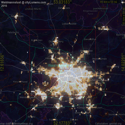
Analysis of Waidmannslust night lights 2016
Square area 10x10 km:
 13.49%
90-99
17.86%80-89
5.03%70-79
6.75%60-69
6.88%50-59
7.14%40-49
7.41%30-39
12.7%20-29
15.34%10-19
7.41%0-9
0%Square area 50x50 km:
10.33%90-99
8.79%80-89
3.37%70-79
2.67%60-69
2.86%50-59
2.95%40-49
3.16%30-39
3.59%20-29
5.95%10-19
10.34%0-9
45.99%Clear (daylight) street map image can be seen on geolist.org.
Map coordinates:
53° 1' 54.6" North, 12° 36' 59.6" East
52° 36' 24.9" North, 13° 19' 10.8" East
52° 10' 40.2" North, 14° 1' 22.1" East
Some cities around Waidmannslust sort by population:
• Märkisches Viertel
2.7 km =1.7 mi,  110°
110°
• Tegel
3.9 km =2.4 mi,  206°
206°
• Wittenau
1.5 km =0.9 mi,  175°
175°
• Frohnau
3.5 km =2.2 mi,  325°
325°
• Hermsdorf
1.2 km =0.7 mi,  311°
311°
• Glienicke
3 km =1.9 mi,  7°
7°
• Rosenthal
4 km =2.5 mi,  101°
101°
• Wilhelmsruh
4 km =2.5 mi,  123°
123°
8334623 (p: 9,715)
Sources (retrieved 2019-11-25):
» Earth at Night: Flat Maps 2012, 2016