Frohnau night lights from space
Night Light of Frohnau (Berlin) from space (Germany) Src. Average luminocity for 10x10km area is 39.3981% and for 50x50km: 30.0905%.
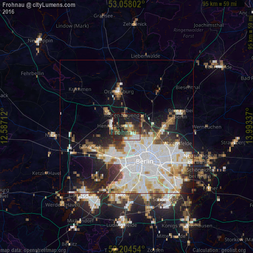
Analysis of Frohnau night lights 2016
Square area 10x10 km:
 3.84%
3.84%90-99
7.54%80-89
2.12%70-79
4.1%60-69
7.01%50-59
7.94%40-49
6.61%30-39
8.47%20-29
17.06%10-19
31.48%0-9
3.84%Square area 50x50 km:
9.63%90-99
7.94%80-89
3.04%70-79
2.39%60-69
2.38%50-59
2.6%40-49
2.64%30-39
2.87%20-29
5.19%10-19
9.07%0-9
52.25%Clear (daylight) street map image can be seen on geolist.org.
Map coordinates:
53° 3' 28.9" North, 12° 35' 13.6" East
52° 38' 0.1" North, 13° 17' 24.9" East
52° 12' 16.3" North, 13° 59' 36.1" East
Some cities around Frohnau sort by population:
• Märkisches Viertel
6 km =3.7 mi,  130°
130°
• Wittenau
4.9 km =3 mi,  154°
154°
• Hennigsdorf
5.8 km =3.6 mi,  272°
272°
• Hohen Neuendorf
4.8 km =3 mi,  349°
349°
• Heiligensee
3.7 km =2.3 mi,  235°
235°
• Hermsdorf
2.4 km =1.5 mi, 153°
• Waidmannslust
3.5 km =2.2 mi, 145°
• Glienicke
2.4 km =1.5 mi,  89°
89°
2924302 (p: 16,571)
Sources (retrieved 2019-11-25):
» Earth at Night: Flat Maps 2012, 2016