Glienicke night lights from space
Night Light of Glienicke (Brandenburg) from space (Germany) Src. Average luminocity for 10x10km area is 42.754% and for 50x50km: 30.4286%.
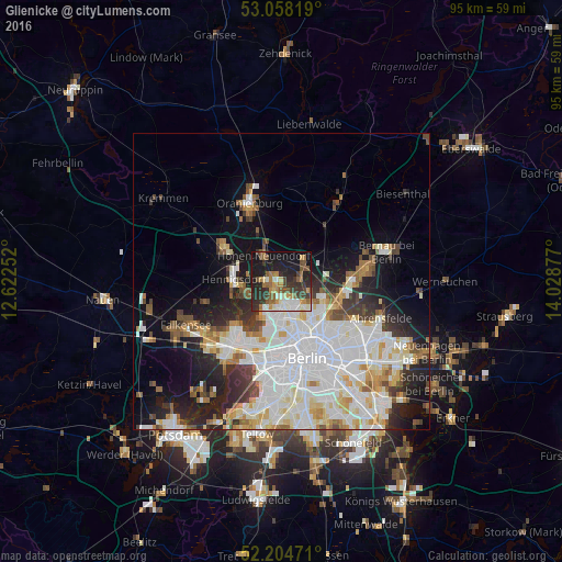
Analysis of Glienicke night lights 2016
Square area 10x10 km:
 4.1%
4.1%90-99
9.13%80-89
1.98%70-79
6.08%60-69
7.41%50-59
7.8%40-49
8.47%30-39
10.32%20-29
14.81%10-19
24.21%0-9
5.69%Square area 50x50 km:
9.61%90-99
7.95%80-89
3.05%70-79
2.39%60-69
2.48%50-59
2.67%40-49
2.82%30-39
2.94%20-29
5.3%10-19
9.82%0-9
50.95%Clear (daylight) street map image can be seen on geolist.org.
Map coordinates:
53° 3' 29.5" North, 12° 37' 21.1" East
52° 38' 0.7" North, 13° 19' 32.3" East
52° 12' 17" North, 14° 1' 43.6" East
Some cities around Glienicke sort by population:
• Märkisches Viertel
4.5 km =2.8 mi,  151°
151°
• Wittenau
4.5 km =2.8 mi,  183°
183°
• Hohen Neuendorf
5.7 km =3.5 mi,  325°
325°
• Heiligensee
5.8 km =3.6 mi,  248°
248°
• Frohnau
2.4 km =1.5 mi,  269°
269°
• Hermsdorf
2.5 km =1.6 mi,  211°
211°
• Waidmannslust
3 km =1.9 mi,  187°
187°
• Rosenthal
5.1 km =3.2 mi,  136°
136°
2919908 (p: 9,144)
Sources (retrieved 2019-11-25):
» Earth at Night: Flat Maps 2012, 2016