Frohburg night lights from space
Night Light of Frohburg (Saxony) from space (Germany) Src. Average luminocity for 10x10km area is 1.611% and for 50x50km: 4.315%.
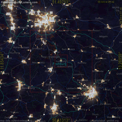
Analysis of Frohburg night lights 2016
Square area 10x10 km:
 0%
0%90-99
0%80-89
0.27%70-79
0.27%60-69
0%50-59
0%40-49
0.13%30-39
2.01%20-29
0%10-19
0%0-9
97.33%Square area 50x50 km:
0.36%90-99
0.57%80-89
0.47%70-79
0.46%60-69
0.61%50-59
0.79%40-49
0.42%30-39
0.61%20-29
0.86%10-19
3.05%0-9
91.8%Clear (daylight) street map image can be seen on geolist.org.
Map coordinates:
51° 29' 49.3" North, 11° 51' 15.6" East
51° 3' 25.9" North, 12° 33' 26.9" East
50° 36' 47.3" North, 13° 15' 38.1" East
Some cities around Frohburg sort by population:
• Altenburg
11.4 km =7.1 mi,  227°
227°
• Borna
8.6 km =5.3 mi,  330°
330°
• Penig
17.2 km =10.7 mi,  143°
143°
• Bad Lausick
11.5 km =7.1 mi,  31°
31°
• Rochlitz
16.8 km =10.4 mi,  92°
92°
• Geithain
9.7 km =6 mi, 91°
• Kitzscher
11.9 km =7.4 mi,  358°
358°
• Lunzenau
17.4 km =10.8 mi,  127°
127°
2924313 (p: 7,983)
Sources (retrieved 2019-11-25):
» Earth at Night: Flat Maps 2012, 2016