Freisen night lights from space
Night Light of Freisen (Saarland) from space (Germany) Src. Average luminocity for 10x10km area is 1.0546% and for 50x50km: 5.6409%.
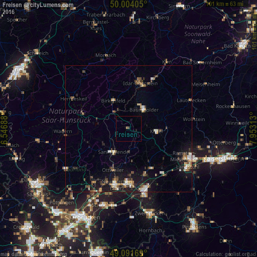
Analysis of Freisen night lights 2016
Square area 10x10 km:
 0%
0%90-99
0%80-89
0%70-79
0%60-69
0.56%50-59
0%40-49
0.56%30-39
0%20-29
0.56%10-19
0.28%0-9
98.04%Square area 50x50 km:
0.57%90-99
0.75%80-89
0.63%70-79
0.52%60-69
0.63%50-59
0.75%40-49
1.11%30-39
0.91%20-29
1.16%10-19
5.02%0-9
87.94%Clear (daylight) street map image can be seen on geolist.org.
Map coordinates:
50° 0' 14.6" North, 6° 32' 48.8" East
49° 33' 0" North, 7° 15' 0" East
49° 5' 30.1" North, 7° 57' 11.3" East
Some cities around Freisen sort by population:
• Sankt Wendel
11 km =6.8 mi,  212°
212°
• Tholey
17.1 km =10.6 mi,  244°
244°
• Marpingen
17.6 km =10.9 mi,  231°
231°
• Nohfelden
8.8 km =5.5 mi,  297°
297°
• Namborn
8.5 km =5.3 mi,  248°
248°
• Birkenfeld
12.9 km =8 mi,  332°
332°
• Oberthal
12.7 km =7.9 mi, 250°
• Kusel
11.2 km =7 mi,  96°
96°
2925038 (p: 8,778)
Sources (retrieved 2019-11-25):
» Earth at Night: Flat Maps 2012, 2016