Oberthal night lights from space
Night Light of Oberthal (Saarland) from space (Germany) Src. Average luminocity for 10x10km area is 1.5588% and for 50x50km: 7.6478%.
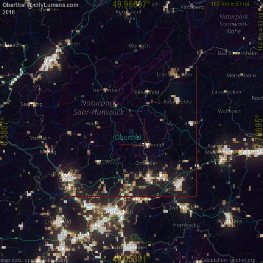
Analysis of Oberthal night lights 2016
Square area 10x10 km:
 0.42%
0.42%90-99
0.14%80-89
0%70-79
0%60-69
0%50-59
0%40-49
0%30-39
0%20-29
1.96%10-19
1.26%0-9
96.22%Square area 50x50 km:
0.7%90-99
0.91%80-89
0.72%70-79
0.65%60-69
0.91%50-59
1.22%40-49
1.64%30-39
1.26%20-29
1.98%10-19
8.52%0-9
81.49%Clear (daylight) street map image can be seen on geolist.org.
Map coordinates:
49° 58' 1.1" North, 6° 22' 50.5" East
49° 30' 45.3" North, 7° 5' 1.8" East
49° 3' 14.1" North, 7° 47' 13" East
Some cities around Oberthal sort by population:
• Sankt Wendel
8 km =5 mi,  130°
130°
• Ottweiler
13.7 km =8.5 mi,  154°
154°
• Tholey
4.7 km =2.9 mi,  226°
226°
• Marpingen
7 km =4.3 mi,  195°
195°
• Nohfelden
9.3 km =5.8 mi,  27°
27°
• Nonnweiler
13.4 km =8.3 mi,  322°
322°
• Freisen
12.7 km =7.9 mi,  70°
70°
• Namborn
4.2 km =2.6 mi,  76°
76°
2858807 (p: 6,581)
Sources (retrieved 2019-11-25):
» Earth at Night: Flat Maps 2012, 2016