Dahlem night lights from space
Night Light of Dahlem (Berlin) from space (Germany) Src. Average luminocity for 10x10km area is 81.9912% and for 50x50km: 37.8954%.
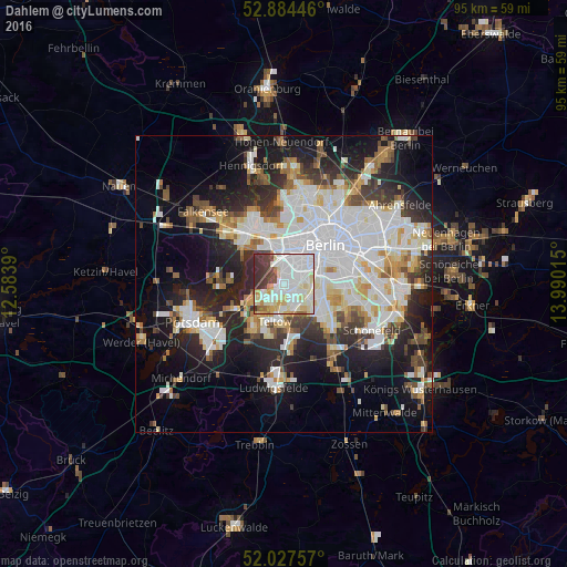
Analysis of Dahlem night lights 2016
Square area 10x10 km:
 29.92%
90-99
30.68%80-89
11.36%70-79
3.54%60-69
3.03%50-59
2.78%40-49
5.43%30-39
10.48%20-29
2.78%10-19
0%0-9
0%Square area 50x50 km:
11.09%90-99
9.56%80-89
3.69%70-79
2.99%60-69
3.16%50-59
3.42%40-49
3.74%30-39
4.22%20-29
8.6%10-19
14.78%0-9
34.75%Clear (daylight) street map image can be seen on geolist.org.
Map coordinates:
52° 53' 4.1" North, 12° 35' 2" East
52° 27' 29.2" North, 13° 17' 13.3" East
52° 1' 39.3" North, 13° 59' 24.5" East
Some cities around Dahlem sort by population:
• Wilmersdorf
3.5 km =2.2 mi,  35°
35°
• Lichterfelde
3.1 km =1.9 mi,  153°
153°
• Steglitz
3.1 km =1.9 mi,  94°
94°
• Zehlendorf
3.7 km =2.3 mi,  222°
222°
• Friedenau
3.1 km =1.9 mi,  62°
62°
• Schmargendorf
1.9 km =1.2 mi,  7°
7°
• Halensee
3.6 km =2.2 mi, 9°
• Grunewald
3.2 km =2 mi,  332°
332°
2939440 (p: 15,737)
Sources (retrieved 2019-11-25):
» Earth at Night: Flat Maps 2012, 2016