Grunewald night lights from space
Night Light of Grunewald (Berlin) from space (Germany) Src. Average luminocity for 10x10km area is 76.0265% and for 50x50km: 37.6748%.
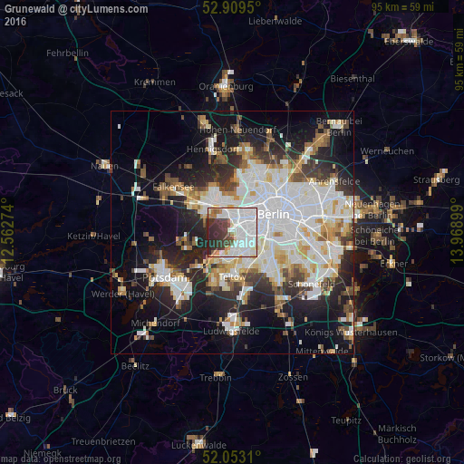
Analysis of Grunewald night lights 2016
Square area 10x10 km:
 35.98%
90-99
21.72%80-89
4.17%70-79
1.89%60-69
5.05%50-59
2.15%40-49
6.06%30-39
11.74%20-29
10.98%10-19
0.25%0-9
0%Square area 50x50 km:
11.05%90-99
9.51%80-89
3.67%70-79
2.99%60-69
3.15%50-59
3.36%40-49
3.8%30-39
4.15%20-29
8.32%10-19
14.34%0-9
35.67%Clear (daylight) street map image can be seen on geolist.org.
Map coordinates:
52° 54' 34.2" North, 12° 33' 45.9" East
52° 29' 0.2" North, 13° 15' 57.1" East
52° 3' 11.2" North, 13° 58' 8.4" East
Some cities around Grunewald sort by population:
• Charlottenburg
3.9 km =2.4 mi,  17°
17°
• Wilmersdorf
3.4 km =2.1 mi,  90°
90°
• Steglitz
5.4 km =3.4 mi,  124°
124°
• Westend
3.8 km =2.4 mi,  10°
10°
• Friedenau
4.4 km =2.7 mi,  107°
107°
• Schmargendorf
1.9 km =1.2 mi, 118°
• Dahlem
3.2 km =2 mi,  152°
152°
• Halensee
2.2 km =1.4 mi,  70°
70°
2914210 (p: 11,631)
Sources (retrieved 2019-11-25):
» Earth at Night: Flat Maps 2012, 2016