Bad Aibling night lights from space
Night Light of Bad Aibling (Bavaria) from space (Germany) Src. Average luminocity for 10x10km area is 12.1918% and for 50x50km: 2.9659%.
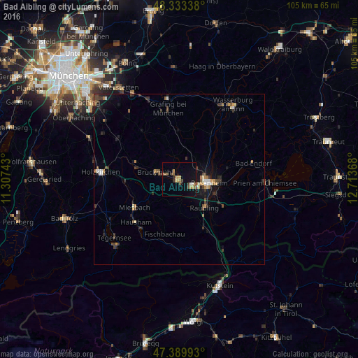
Analysis of Bad Aibling night lights 2016
Square area 10x10 km:
 0.43%
0.43%90-99
0.71%80-89
0.99%70-79
2.98%60-69
2.84%50-59
2.27%40-49
2.13%30-39
0.71%20-29
0.43%10-19
6.82%0-9
79.69%Square area 50x50 km:
0.2%90-99
0.29%80-89
0.19%70-79
0.43%60-69
0.43%50-59
0.42%40-49
0.57%30-39
0.7%20-29
0.66%10-19
2.31%0-9
93.78%Clear (daylight) street map image can be seen on geolist.org.
Map coordinates:
48° 20' 0.2" North, 11° 18' 26.7" East
47° 51' 49.7" North, 12° 0' 38" East
47° 23' 23.7" North, 12° 42' 49.2" East
Some cities around Bad Aibling sort by population:
• Rosenheim
8.4 km =5.2 mi,  95°
95°
• Kolbermoor
4.5 km =2.8 mi,  110°
110°
• Bruckmühl
7.6 km =4.7 mi,  282°
282°
• Raubling
11.1 km =6.9 mi,  137°
137°
• Stephanskirchen
13.1 km =8.1 mi,  94°
94°
• Bad Feilnbach
10.1 km =6.3 mi,  180°
180°
• Großkarolinenfeld
6.1 km =3.8 mi,  60°
60°
• Tuntenhausen
7.9 km =4.9 mi,  2°
2°
2953558 (p: 17,672)
Sources (retrieved 2019-11-25):
» Earth at Night: Flat Maps 2012, 2016