Stephanskirchen night lights from space
Night Light of Stephanskirchen (Bavaria) from space (Germany) Src. Average luminocity for 10x10km area is 10.1719% and for 50x50km: 2.1237%.
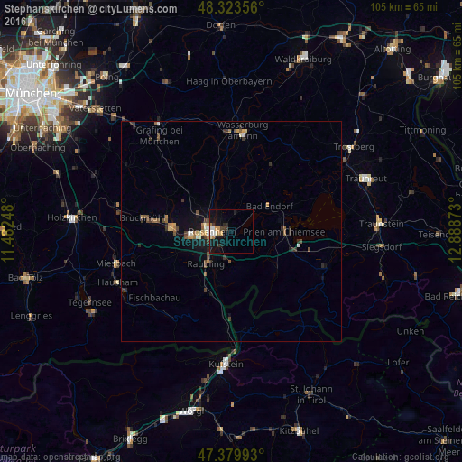
Analysis of Stephanskirchen night lights 2016
Square area 10x10 km:
 1.28%
1.28%90-99
1.56%80-89
0.57%70-79
1.7%60-69
1.7%50-59
0%40-49
0.43%30-39
2.41%20-29
1.56%10-19
13.07%0-9
75.71%Square area 50x50 km:
0.13%90-99
0.22%80-89
0.17%70-79
0.37%60-69
0.26%50-59
0.36%40-49
0.34%30-39
0.53%20-29
0.39%10-19
1.54%0-9
95.69%Clear (daylight) street map image can be seen on geolist.org.
Map coordinates:
48° 19' 24.8" North, 11° 28' 56.9" East
47° 51' 14" North, 12° 11' 8.2" East
47° 22' 47.7" North, 12° 53' 19.4" East
Some cities around Stephanskirchen sort by population:
• Rosenheim
4.7 km =2.9 mi,  273°
273°
• Kolbermoor
8.9 km =5.5 mi, 266°
• Raubling
9 km =5.6 mi,  218°
218°
• Prien am Chiemsee
12 km =7.5 mi,  88°
88°
• Bad Endorf
10.4 km =6.5 mi,  53°
53°
• Großkarolinenfeld
8.8 km =5.5 mi,  297°
297°
• Rohrdorf
6.4 km =4 mi,  190°
190°
• Riedering
2.4 km =1.5 mi,  135°
135°
2827406 (p: 9,554)
Sources (retrieved 2019-11-25):
» Earth at Night: Flat Maps 2012, 2016