Asbach night lights from space
Night Light of Asbach (Rheinland-Pfalz) from space (Germany) Src. Average luminocity for 10x10km area is 2.8382% and for 50x50km: 10.3247%.
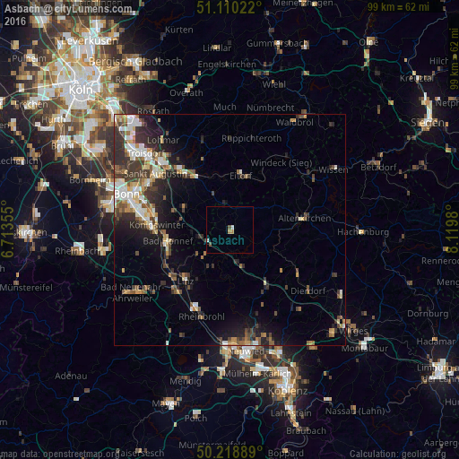
Analysis of Asbach night lights 2016
Square area 10x10 km:
 0.27%
0.27%90-99
0.8%80-89
0%70-79
0.27%60-69
0.8%50-59
0.53%40-49
0.53%30-39
0%20-29
0%10-19
0%0-9
96.79%Square area 50x50 km:
1.43%90-99
1.74%80-89
0.99%70-79
1.02%60-69
1.42%50-59
1.53%40-49
1.54%30-39
2.54%20-29
3.03%10-19
4.94%0-9
79.84%Clear (daylight) street map image can be seen on geolist.org.
Map coordinates:
51° 6' 36.8" North, 6° 42' 48.8" East
50° 40' 0" North, 7° 25' 0" East
50° 13' 8" North, 8° 7' 11.3" East
Some cities around Asbach sort by population:
• Hennef
15.3 km =9.5 mi,  322°
322°
• Königswinter
16.3 km =10.1 mi,  276°
276°
• Bad Honnef
13.6 km =8.5 mi,  258°
258°
• Eitorf
11.4 km =7.1 mi,  11°
11°
• Remagen
16.6 km =10.3 mi,  233°
233°
• Altenkirchen
16 km =9.9 mi,  82°
82°
• Linz am Rhein
14.3 km =8.9 mi,  220°
220°
• Bad Hönningen
18.2 km =11.3 mi,  203°
203°
2955315 (p: 7,060)
Sources (retrieved 2019-11-25):
» Earth at Night: Flat Maps 2012, 2016