Bad Hönningen night lights from space
Night Light of Bad Hönningen (Rheinland-Pfalz) from space (Germany) Src. Average luminocity for 10x10km area is 8.5896% and for 50x50km: 11.1317%.
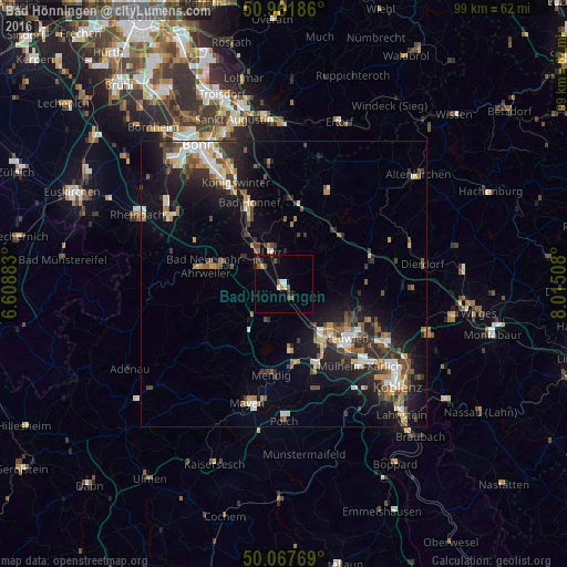
Analysis of Bad Hönningen night lights 2016
Square area 10x10 km:
 1.12%
1.12%90-99
0.56%80-89
0.56%70-79
0.98%60-69
0.98%50-59
1.82%40-49
2.1%30-39
0.7%20-29
1.54%10-19
0.7%0-9
88.94%Square area 50x50 km:
1.32%90-99
1.89%80-89
0.92%70-79
0.97%60-69
1.54%50-59
1.82%40-49
1.95%30-39
1.59%20-29
3.47%10-19
7.98%0-9
76.55%Clear (daylight) street map image can be seen on geolist.org.
Map coordinates:
50° 57' 42.7" North, 6° 36' 31.8" East
50° 31' 0.8" North, 7° 18' 43" East
50° 4' 3.7" North, 8° 0' 54.3" East
Some cities around Bad Hönningen sort by population:
• Neuwied
14.6 km =9.1 mi,  129°
129°
• Andernach
11.6 km =7.2 mi,  145°
145°
• Bad Neuenahr-Ahrweiler
14.5 km =9 mi,  281°
281°
• Sinzig
5.5 km =3.4 mi,  302°
302°
• Remagen
9.1 km =5.7 mi,  318°
318°
• Bad Breisig
2.1 km =1.3 mi,  231°
231°
• Weißenthurm
14.8 km =9.2 mi,  138°
138°
• Linz am Rhein
6.1 km =3.8 mi,  341°
341°
2953434 (p: 5,772)
Sources (retrieved 2019-11-25):
» Earth at Night: Flat Maps 2012, 2016