Remagen night lights from space
Night Light of Remagen (Rheinland-Pfalz) from space (Germany) Src. Average luminocity for 10x10km area is 12.885% and for 50x50km: 12.6851%.
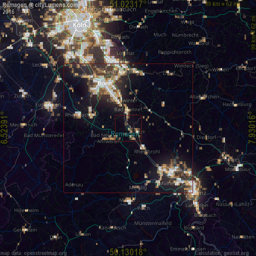
Analysis of Remagen night lights 2016
Square area 10x10 km:
 0.27%
0.27%90-99
0.53%80-89
0.53%70-79
1.6%60-69
1.34%50-59
2.27%40-49
5.88%30-39
3.74%20-29
2.54%10-19
2.81%0-9
78.48%Square area 50x50 km:
1.49%90-99
2.09%80-89
1.21%70-79
1.17%60-69
1.85%50-59
1.88%40-49
2.05%30-39
2.63%20-29
4.61%10-19
7.57%0-9
73.45%Clear (daylight) street map image can be seen on geolist.org.
Map coordinates:
51° 1' 23.4" North, 6° 31' 26.1" East
50° 34' 43.6" North, 7° 13' 37.3" East
50° 7' 48.6" North, 7° 55' 48.6" East
Some cities around Remagen sort by population:
• Königswinter
12 km =7.5 mi,  346°
346°
• Bad Neuenahr-Ahrweiler
9.1 km =5.7 mi,  244°
244°
• Bad Honnef
7.2 km =4.5 mi,  0°
0°
• Wachtberg
10.8 km =6.7 mi,  304°
304°
• Sinzig
4.1 km =2.5 mi,  160°
160°
• Bad Breisig
9.3 km =5.8 mi,  151°
151°
• Linz am Rhein
4.2 km =2.6 mi,  105°
105°
• Bad Hönningen
9.1 km =5.7 mi,  138°
138°
2848335 (p: 16,280)
Sources (retrieved 2019-11-25):
» Earth at Night: Flat Maps 2012, 2016