Alfter night lights from space
Night Light of Alfter (North Rhine-Westphalia) from space (Germany) Src. Average luminocity for 10x10km area is 40.369% and for 50x50km: 23.136%.
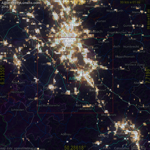
Analysis of Alfter night lights 2016
Square area 10x10 km:
 8.29%
8.29%90-99
8.42%80-89
3.48%70-79
3.88%60-69
3.07%50-59
6.02%40-49
8.02%30-39
8.42%20-29
10.43%10-19
19.79%0-9
20.19%Square area 50x50 km:
4.32%90-99
4.61%80-89
2.09%70-79
1.84%60-69
3.13%50-59
3.19%40-49
3.26%30-39
4.52%20-29
6.68%10-19
11.05%0-9
55.33%Clear (daylight) street map image can be seen on geolist.org.
Map coordinates:
51° 10' 34.5" North, 6° 18' 48.8" East
50° 43' 60" North, 7° 1' 0" East
50° 17' 10.2" North, 7° 43' 11.3" East
Some cities around Alfter sort by population:
• Bonn
5.5 km =3.4 mi,  88°
88°
• Troisdorf
12.6 km =7.8 mi,  48°
48°
• Bornheim
3.8 km =2.4 mi,  331°
331°
• Niederkassel
9.2 km =5.7 mi,  9°
9°
• Wesseling
10.8 km =6.7 mi,  344°
344°
• Meckenheim
12.2 km =7.6 mi,  175°
175°
• Wachtberg
12.6 km =7.8 mi,  152°
152°
• Weilerswist
12.2 km =7.6 mi,  280°
280°
2958516 (p: 21,814)
Sources (retrieved 2019-11-25):
» Earth at Night: Flat Maps 2012, 2016