Kralupy nad Vltavou night lights from space
Night Light of Kralupy nad Vltavou (Central Bohemia) from space (Czech Republic) Src. Average luminocity for 10x10km area is 22.7861% and for 50x50km: 20.523%.
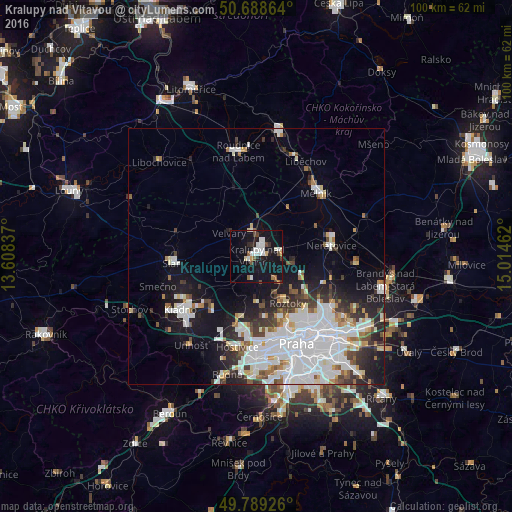
Analysis of Kralupy nad Vltavou night lights 2016
Square area 10x10 km:
 5.08%
5.08%90-99
4.81%80-89
1.6%70-79
0.8%60-69
1.34%50-59
2.54%40-49
1.87%30-39
1.74%20-29
2.41%10-19
39.44%0-9
38.37%Square area 50x50 km:
7.36%90-99
4.61%80-89
1.35%70-79
1.23%60-69
1.5%50-59
1.47%40-49
1.58%30-39
2.38%20-29
3.91%10-19
9.79%0-9
64.81%Clear (daylight) street map image can be seen on geolist.org.
Map coordinates:
50° 41' 19.1" North, 13° 36' 30.1" East
50° 14' 27.9" North, 14° 18' 41.4" East
49° 47' 21.3" North, 15° 0' 52.6" East
Some cities around Kralupy nad Vltavou sort by population:
• Prague
18.7 km =11.6 mi,  155°
155°
• Kladno
18.1 km =11.2 mi,  234°
234°
• Mělník
16.8 km =10.4 mi,  43°
43°
• Neratovice
14.8 km =9.2 mi,  82°
82°
• Slaný
16 km =9.9 mi,  265°
265°
• Střížkov
18.2 km =11.3 mi,  134°
134°
• Malá Strana
18.3 km =11.4 mi, 158°
• Roztoky
11 km =6.8 mi,  146°
146°
3072929 (p: 17,373)
Sources (retrieved 2019-11-25):
» Earth at Night: Flat Maps 2012, 2016