Slaný night lights from space
Night Light of Slaný (Central Bohemia) from space (Czech Republic) Src. Average luminocity for 10x10km area is 8.8128% and for 50x50km: 12.3505%.
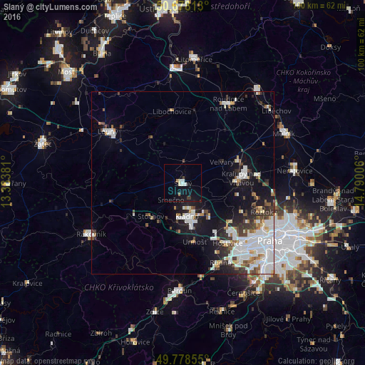
Analysis of Slaný night lights 2016
Square area 10x10 km:
 1.74%
1.74%90-99
1.34%80-89
0.67%70-79
0%60-69
0.8%50-59
0.27%40-49
0.53%30-39
1.2%20-29
0.27%10-19
12.43%0-9
80.75%Square area 50x50 km:
3.74%90-99
2.93%80-89
0.82%70-79
0.61%60-69
0.98%50-59
0.89%40-49
1.2%30-39
1.48%20-29
2.27%10-19
7.55%0-9
77.53%Clear (daylight) street map image can be seen on geolist.org.
Map coordinates:
50° 40' 41.3" North, 13° 23' 1.7" East
50° 13' 49.7" North, 14° 5' 12.9" East
49° 46' 42.8" North, 14° 47' 24.2" East
Some cities around Slaný sort by population:
• Kladno
9.3 km =5.8 mi,  173°
173°
• Louny
25 km =15.5 mi,  304°
304°
• Kralupy nad Vltavou
16 km =9.9 mi,  85°
85°
• Roudnice nad Labem
25 km =15.5 mi,  29°
29°
• Malá Strana
27.6 km =17.1 mi,  125°
125°
• Roztoky
23.5 km =14.6 mi,  109°
109°
• Stochov
12.8 km =8 mi,  223°
223°
• Nové Strašecí
15.8 km =9.8 mi,  236°
236°
3065903 (p: 15,070)
Sources (retrieved 2019-11-25):
» Earth at Night: Flat Maps 2012, 2016