Střížkov night lights from space
Night Light of Střížkov (Hlavní město Praha) from space (Czech Republic) Src. Average luminocity for 10x10km area is 81.139% and for 50x50km: 24.2052%.
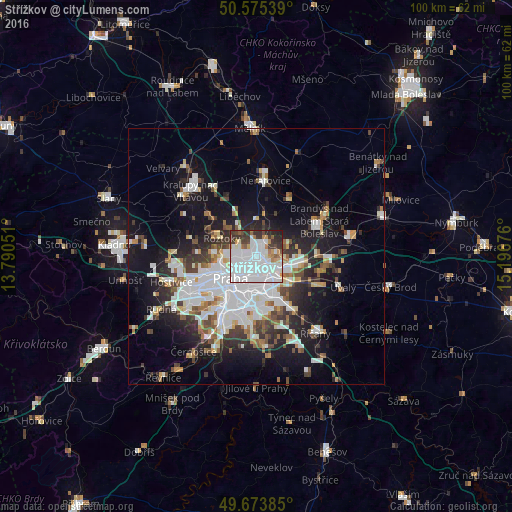
Analysis of Střížkov night lights 2016
Square area 10x10 km:
 50.4%
50.4%90-99
14.57%80-89
2.27%70-79
4.41%60-69
4.28%50-59
2.94%40-49
3.74%30-39
10.96%20-29
5.61%10-19
0.8%0-9
0%Square area 50x50 km:
7.61%90-99
4.97%80-89
1.55%70-79
1.78%60-69
2.06%50-59
2.28%40-49
2.38%30-39
3.3%20-29
5.19%10-19
13.43%0-9
55.47%Clear (daylight) street map image can be seen on geolist.org.
Map coordinates:
50° 34' 31.4" North, 13° 47' 25.8" East
50° 7' 36.3" North, 14° 29' 37.1" East
49° 40' 25.9" North, 15° 11' 48.3" East
Some cities around Střížkov sort by population:
• Prague
6.7 km =4.2 mi,  230°
230°
• Libeň
2.5 km =1.6 mi,  213°
213°
• Černý Most
6.6 km =4.1 mi,  111°
111°
• Letňany
1.8 km =1.1 mi,  65°
65°
• Prosek
1.6 km =1 mi,  143°
143°
• Karlín
5 km =3.1 mi,  221°
221°
• Vysočany
2.5 km =1.6 mi, 139°
• Kbely
4.1 km =2.5 mi,  79°
79°
3064894 (p: 14,069)
Sources (retrieved 2019-11-25):
» Earth at Night: Flat Maps 2012, 2016