Mělník night lights from space
Night Light of Mělník (Central Bohemia) from space (Czech Republic) Src. Average luminocity for 10x10km area is 10.1064% and for 50x50km: 8.262%.
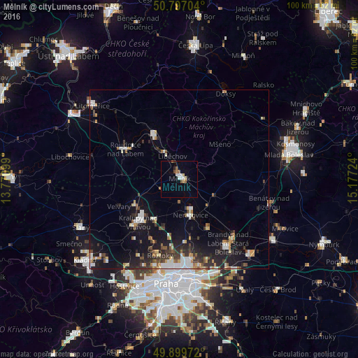
Analysis of Mělník night lights 2016
Square area 10x10 km:
 1.54%
1.54%90-99
1.82%80-89
1.54%70-79
0.14%60-69
1.68%50-59
1.12%40-49
0.84%30-39
0.28%20-29
0.56%10-19
0.42%0-9
90.06%Square area 50x50 km:
1.33%90-99
1.44%80-89
0.57%70-79
0.85%60-69
0.82%50-59
0.76%40-49
0.96%30-39
1.31%20-29
2.31%10-19
7.26%0-9
82.39%Clear (daylight) street map image can be seen on geolist.org.
Map coordinates:
50° 47' 49.3" North, 13° 46' 15.6" East
50° 21' 1.8" North, 14° 28' 26.8" East
49° 53' 59" North, 15° 10' 38.1" East
Some cities around Mělník sort by population:
• Kralupy nad Vltavou
16.8 km =10.4 mi,  223°
223°
• Neratovice
10.6 km =6.6 mi,  163°
163°
• Letňany
24.3 km =15.1 mi,  172°
172°
• Brandýs nad Labem-Stará Boleslav
22.6 km =14 mi,  143°
143°
• Roudnice nad Labem
17.2 km =10.7 mi,  298°
298°
• Štětí
13.4 km =8.3 mi,  328°
328°
• Roztoky
22 km =13.7 mi,  194°
194°
• Kbely
24.7 km =15.3 mi, 167°
3070862 (p: 19,231)
Sources (retrieved 2019-11-25):
» Earth at Night: Flat Maps 2012, 2016