Neratovice night lights from space
Night Light of Neratovice (Central Bohemia) from space (Czech Republic) Src. Average luminocity for 10x10km area is 11.2206% and for 50x50km: 18.5697%.
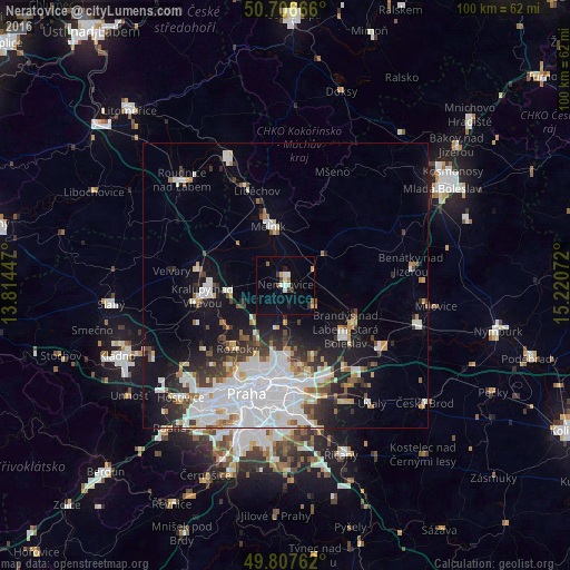
Analysis of Neratovice night lights 2016
Square area 10x10 km:
 1.07%
1.07%90-99
2.27%80-89
1.34%70-79
0.67%60-69
1.2%50-59
0.94%40-49
0.67%30-39
2.01%20-29
0.8%10-19
1.34%0-9
87.7%Square area 50x50 km:
6.52%90-99
3.85%80-89
1.2%70-79
1.33%60-69
1.5%50-59
1.31%40-49
1.41%30-39
2.17%20-29
3.52%10-19
9.12%0-9
68.06%Clear (daylight) street map image can be seen on geolist.org.
Map coordinates:
50° 42' 24" North, 13° 48' 52.1" East
50° 15' 33.3" North, 14° 31' 3.3" East
49° 48' 27.4" North, 15° 13' 14.6" East
Some cities around Neratovice sort by population:
• Mělník
10.6 km =6.6 mi,  343°
343°
• Kralupy nad Vltavou
14.8 km =9.2 mi,  262°
262°
• Letňany
14 km =8.7 mi,  180°
180°
• Prosek
16 km =9.9 mi, 182°
• Brandýs nad Labem-Stará Boleslav
13.1 km =8.1 mi,  127°
127°
• Střížkov
14.8 km =9.2 mi,  186°
186°
• Roztoky
14.1 km =8.8 mi,  217°
217°
• Kbely
14.2 km =8.8 mi,  170°
170°
3069844 (p: 16,427)
Sources (retrieved 2019-11-25):
» Earth at Night: Flat Maps 2012, 2016