Cabañas night lights from space
Night Light of Cabañas (Artemisa) from space (Cuba) Src. Average luminocity for 10x10km area is 7.2996% and for 50x50km: 4.9118%.
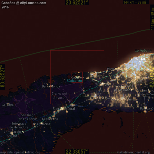
Analysis of Cabañas night lights 2016
Square area 10x10 km:
 0%
0%90-99
0%80-89
0%70-79
2.98%60-69
0.99%50-59
1.59%40-49
1.59%30-39
2.18%20-29
3.17%10-19
2.38%0-9
85.12%Square area 50x50 km:
0.12%90-99
0.2%80-89
0.47%70-79
0.78%60-69
0.56%50-59
0.68%40-49
1.67%30-39
1.35%20-29
1.2%10-19
4.85%0-9
88.12%Clear (daylight) street map image can be seen on geolist.org.
Map coordinates:
23° 37' 30.8" North, 83° 37' 31" West
22° 58' 46" North, 82° 55' 19.7" West
22° 19' 50.1" North, 82° 13' 8.5" West
Some cities around Cabañas sort by population:
• Artemisa
24.6 km =15.3 mi,  137°
137°
• San Cristobal
32.3 km =20.1 mi,  205°
205°
• Bauta
38.4 km =23.9 mi,  89°
89°
• Mariel
17.3 km =10.7 mi, 86°
• Guanajay
24.7 km =15.3 mi,  103°
103°
• Bahía Honda
25.8 km =16 mi,  250°
250°
• Candelaria
26.8 km =16.7 mi,  188°
188°
• Soroa
22.2 km =13.8 mi, 205°
3566573 (p: 5,894)
Sources (retrieved 2019-11-25):
» Earth at Night: Flat Maps 2012, 2016