Candelaria night lights from space
Night Light of Candelaria (Artemisa) from space (Cuba) Src. Average luminocity for 10x10km area is 6.9683% and for 50x50km: 3.8571%.
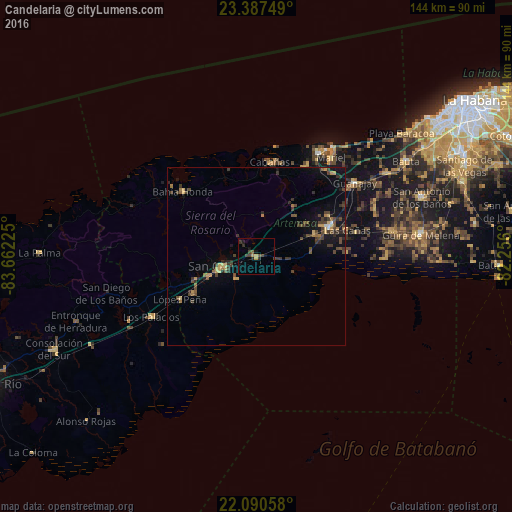
Analysis of Candelaria night lights 2016
Square area 10x10 km:
 0%
0%90-99
0%80-89
0%70-79
2.38%60-69
0%50-59
0.99%40-49
3.77%30-39
1.79%20-29
1.79%10-19
3.57%0-9
85.71%Square area 50x50 km:
0.07%90-99
0.06%80-89
0.42%70-79
0.58%60-69
0.5%50-59
0.46%40-49
1.48%30-39
1.16%20-29
0.9%10-19
2.57%0-9
91.8%Clear (daylight) street map image can be seen on geolist.org.
Map coordinates:
23° 23' 15" North, 83° 39' 44.1" West
22° 44' 26.1" North, 82° 57' 32.8" West
22° 5' 26.1" North, 82° 15' 21.6" West
Some cities around Candelaria sort by population:
• Artemisa
22.2 km =13.8 mi,  67°
67°
• San Cristobal
10.3 km =6.4 mi,  255°
255°
• Mariel
34.8 km =21.6 mi,  37°
37°
• Los Palacios
34 km =21.1 mi,  240°
240°
• Guanajay
34.7 km =21.6 mi,  53°
53°
• Bahía Honda
27.4 km =17 mi,  311°
311°
• Soroa
8.9 km =5.5 mi,  318°
318°
• Cabañas
26.8 km =16.7 mi,  8°
8°
3565768 (p: 12,675)
Sources (retrieved 2019-11-25):
» Earth at Night: Flat Maps 2012, 2016