Villa de Leyva night lights from space
Night Light of Villa de Leyva (Boyacá) from space (Colombia) Src. Average luminocity for 10x10km area is 7.469% and for 50x50km: 3.0706%.
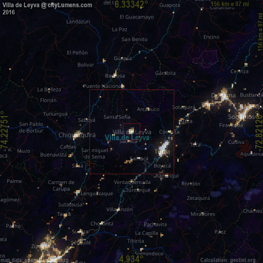
Analysis of Villa de Leyva night lights 2016
Square area 10x10 km:
 0.21%
0.21%90-99
0.62%80-89
0.83%70-79
1.65%60-69
2.27%50-59
1.03%40-49
0.83%30-39
0.62%20-29
2.48%10-19
1.03%0-9
88.43%Square area 50x50 km:
0.47%90-99
0.45%80-89
0.1%70-79
0.3%60-69
0.5%50-59
0.59%40-49
0.3%30-39
0.26%20-29
0.59%10-19
2.58%0-9
93.85%Clear (daylight) street map image can be seen on geolist.org.
Map coordinates:
6° 20' 0.3" North, 74° 13' 39" West
5° 38' 2.9" North, 73° 31' 27.8" West
4° 56' 2.4" North, 72° 49' 16.5" West
Some cities around Villa de Leyva sort by population:
• Tunja
20.5 km =12.7 mi,  122°
122°
• Chiquinquirá
32.5 km =20.2 mi,  266°
266°
• Barbosa
34.6 km =21.5 mi,  343°
343°
• Paipa
47.9 km =29.8 mi,  70°
70°
• Vélez
45.3 km =28.1 mi, 338°
• Moniquirá
27.5 km =17.1 mi,  348°
348°
• Puente Nacional
31.9 km =19.8 mi,  327°
327°
• Ramiriquí
33.4 km =20.8 mi,  141°
141°
3666003 (p: 5,103)
Sources (retrieved 2019-11-25):
» Earth at Night: Flat Maps 2012, 2016