Sitionuevo night lights from space
Night Light of Sitionuevo (Magdalena) from space (Colombia) Src. Average luminocity for 10x10km area is 20.8264% and for 50x50km: 15.2469%.
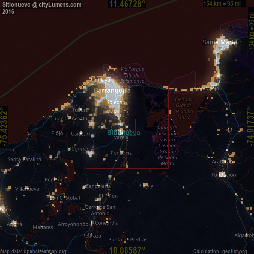
Analysis of Sitionuevo night lights 2016
Square area 10x10 km:
 4.13%
4.13%90-99
2.48%80-89
2.48%70-79
2.48%60-69
5.37%50-59
0.62%40-49
0.62%30-39
2.89%20-29
3.1%10-19
20.66%0-9
55.17%Square area 50x50 km:
4.12%90-99
2.07%80-89
0.83%70-79
2.05%60-69
2.15%50-59
1.58%40-49
2.43%30-39
2.96%20-29
3.47%10-19
6.92%0-9
71.41%Clear (daylight) street map image can be seen on geolist.org.
Map coordinates:
11° 28' 2.2" North, 75° 25' 25" West
10° 46' 38.5" North, 74° 43' 13.8" West
10° 5' 9.1" North, 74° 1' 2.5" West
Some cities around Sitionuevo sort by population:
• Soledad
16.4 km =10.2 mi,  342°
342°
• Malambo
10.8 km =6.7 mi,  327°
327°
• Palmar de Varela
5.5 km =3.4 mi,  222°
222°
• Santo Tomás
4.3 km =2.7 mi,  239°
239°
• Sabanagrande
4.6 km =2.9 mi,  289°
289°
• Polonuevo
14.5 km =9 mi,  269°
269°
• Ponedera
15.4 km =9.6 mi,  193°
193°
• Remolino
8.4 km =5.2 mi,  176°
176°
3667918 (p: 11,817)
Sources (retrieved 2019-11-25):
» Earth at Night: Flat Maps 2012, 2016