Remolino night lights from space
Night Light of Remolino (Magdalena) from space (Colombia) Src. Average luminocity for 10x10km area is 5.3843% and for 50x50km: 9.2311%.
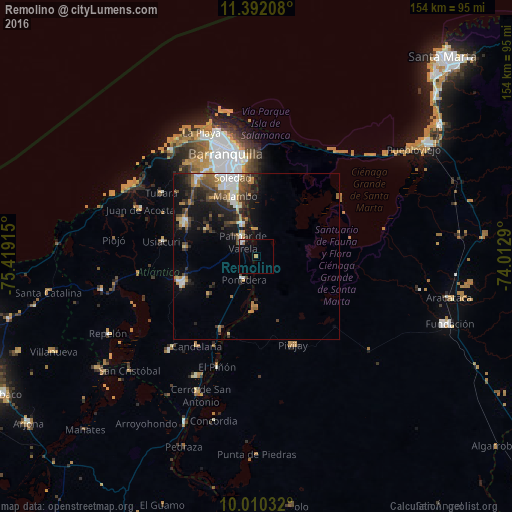
Analysis of Remolino night lights 2016
Square area 10x10 km:
 0.83%
0.83%90-99
1.65%80-89
0%70-79
0.83%60-69
0.83%50-59
0%40-49
0%30-39
0%20-29
0.83%10-19
0.83%0-9
94.21%Square area 50x50 km:
1.57%90-99
1.09%80-89
0.72%70-79
1.14%60-69
1.46%50-59
1.05%40-49
1.61%30-39
2.14%20-29
2.66%10-19
6.04%0-9
80.51%Clear (daylight) street map image can be seen on geolist.org.
Map coordinates:
11° 23' 31.5" North, 75° 25' 8.9" West
10° 42' 7.2" North, 74° 42' 57.7" West
10° 0' 37.2" North, 74° 0' 46.4" West
Some cities around Remolino sort by population:
• Malambo
18.6 km =11.6 mi,  340°
340°
• Sabanalarga
23.9 km =14.9 mi,  250°
250°
• Palmar de Varela
6 km =3.7 mi,  315°
315°
• Santo Tomás
7.5 km =4.7 mi,  325°
325°
• Sabanagrande
11 km =6.8 mi, 333°
• Sitionuevo
8.4 km =5.2 mi,  356°
356°
• Polonuevo
17.2 km =10.7 mi,  299°
299°
• Ponedera
7.8 km =4.8 mi,  212°
212°
3670884 (p: 8,308)
Sources (retrieved 2019-11-25):
» Earth at Night: Flat Maps 2012, 2016